| Photographs of Perth, Western Australia | |||
Bunbury - Photographs of Western Australia The largest community outside of Perth in W.A., the City of Bunbury is 185 kms south of Perth. This city was named after Lt. William St. Pierre Bunbury by Governor Stirling. Lt. Bunbury explored the area in 1836. The town was established in 1841. Recent years has seen large growth and Bunbury has become an increasingly important regional centre complimented with extensive shipping facilities. There is now a dual-carriage highway all the way to Perth |
|||
| North to Binningup | South to Capel | ||
| North to Waterloo | East to Dardanup | ||
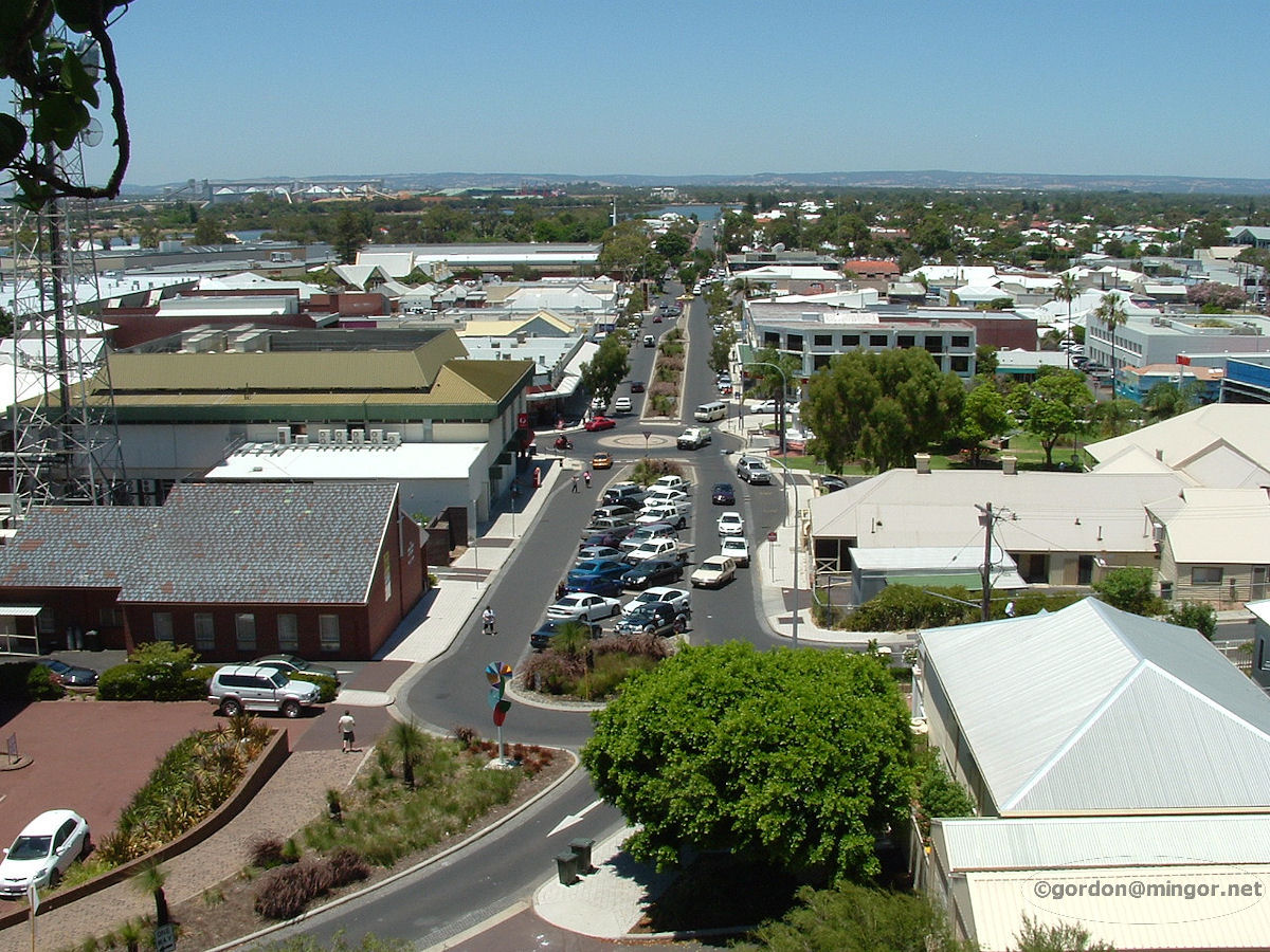 |
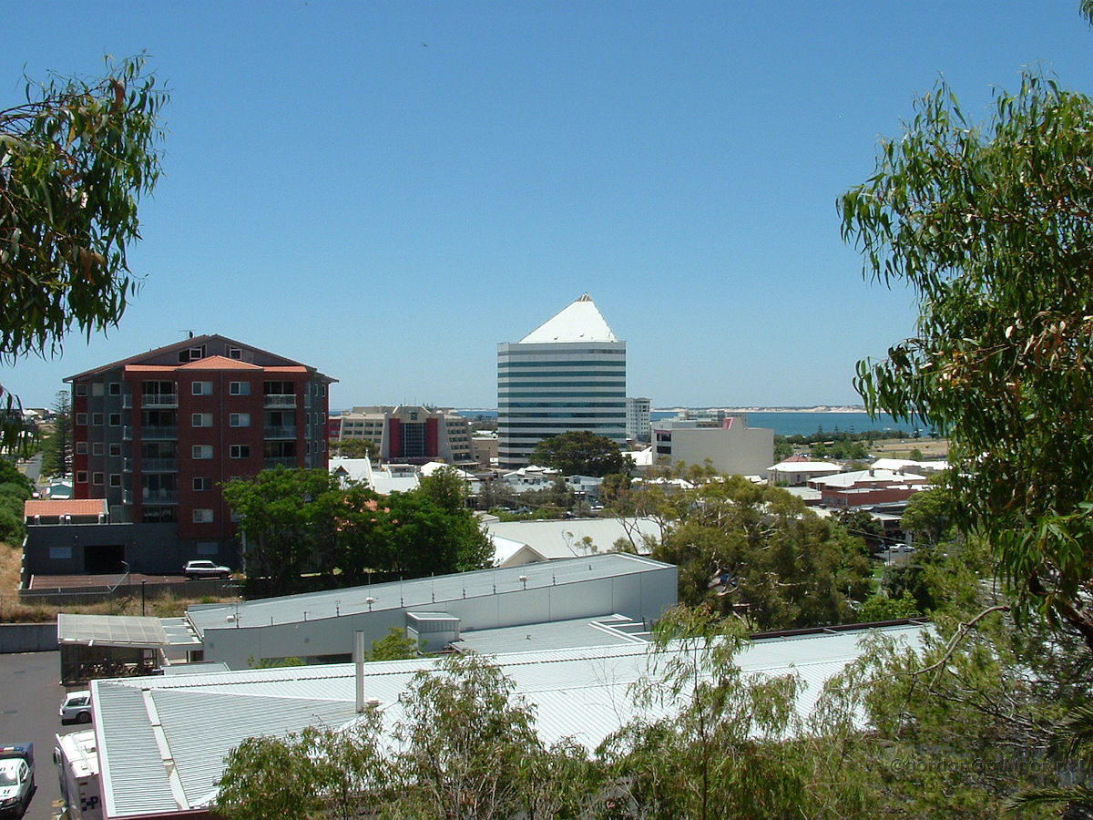
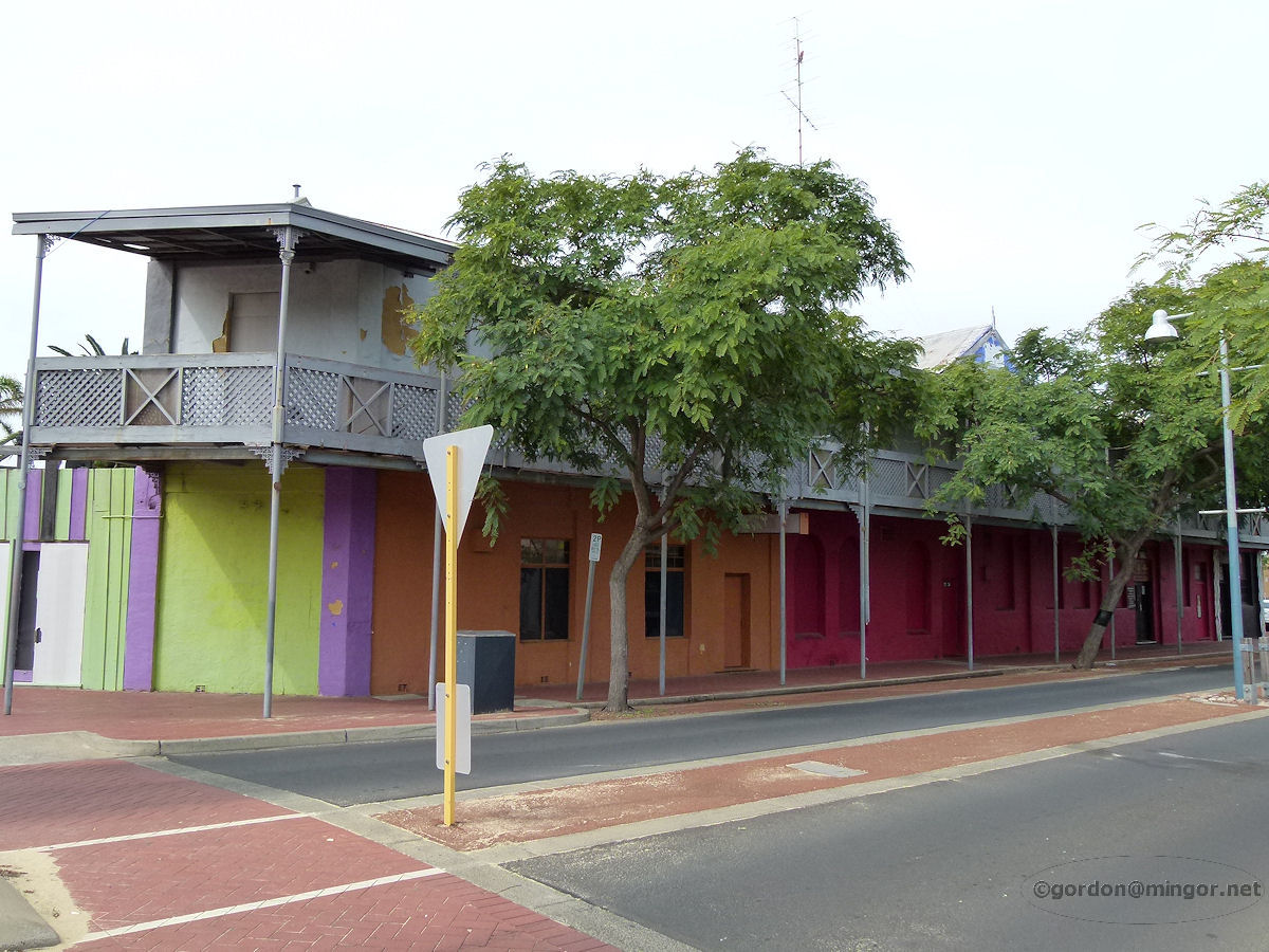
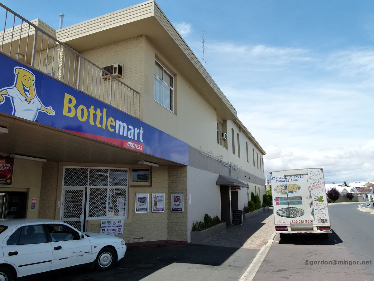
Bunbury - Stirling Street A view from Boulter's Heights looking down Stirling Street, across to the port facilities, and then the hills beyond. Boulter's Heights is a favourite photography spot overlooking the Bunbury townsite. That roundabout on the road is 'new', as is the mid-road car parking. At this south end of Victoria Street used to be D'Raine and Howson butchers and also Sherry's Pharmacy. A little further up was Musgroves music store. December 2009. Photos Ref: BUNB001 |
||
 |
Bunbury - Back Beach from High School Viewed from the High School, this is the Bunbury 'Back Beach' and the surf club rooms. The Bunbury Surf Life Saving Club was formed in 1915. There used to be an older surf club building on this site (The Bright Spot) which was demolished sometime in the 1970's. The Bright Spot included a cafe on the upper concrete deck on the northern side. Down below facing the beach were change rooms. Below was also a hall with catering facilities and also a boat shed. I was in that boat shed at the time of the Meckering earthquake in 1968. All the boats started rocking in their cradles. Weird. January 2013. Photos Ref: BUNB002 |
||
 |
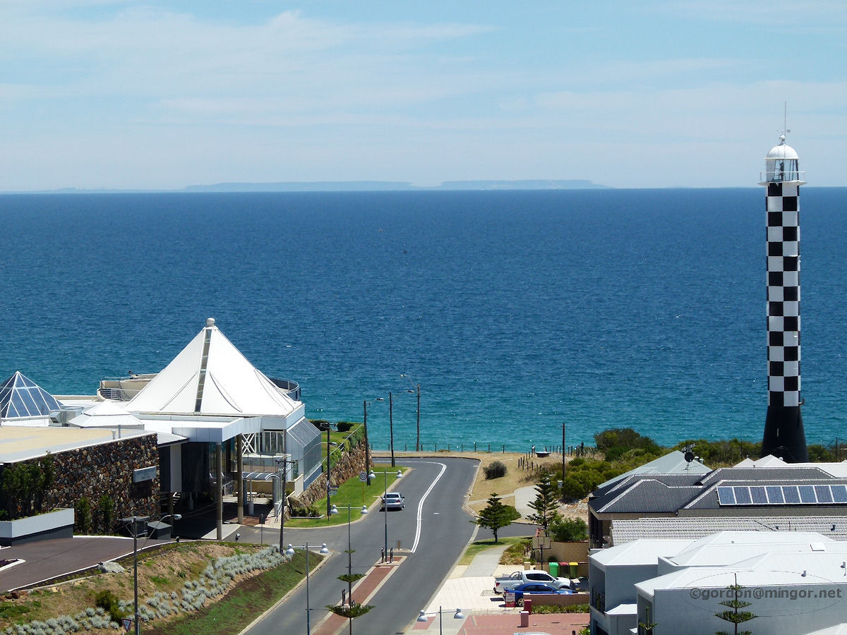
Bunbury - Ocean and Lighthouse Looking almost north from the High School. Visible is the Casuarina Lighthouse on the upper right. It was constructed in 1971. On the lighthouse site is also The Lighthouse Resort. Ships await at sea. In the foreground are beach houses and roads. January 2013. Photos Ref: BUNB003 |
||
 |
Bunbury - Wesley Centre The Wesley Centre is at 4 Stirling Street. This is the site of the Wesleyan Methodist Church and Manse built in 1886. They were demolished in the early 1970's, as were the old post office and court house on Stephen Street. December 2016. Photos Ref: BUNB004 |
||
 |
Bunbury - Teede House At Number 1 Stirling Street is the former Teede House, now part of the Senior Citizen's Centre, Meals on Wheels. This house was erected for the Teede family in approx 1877. Mr George Teede, the first house occupant, was a man of many talents - school teacher, town administrator, and Clerk of Courts. In 1921 the house became a maternity hospital through the efforts of Matron Mary Watts. The Teede family continues to be a well-known family in the district. December 2016. Photos Ref: BUNB005 |
||
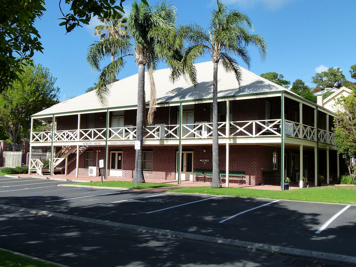 |
Bunbury - Stirling House Set back behind Teede's House is Stirling House which is now also part of the Senior Citizen's Centre. This appears to be the maternity wing of the Bunbury District Hospital, which was closed in the 1960's, probably when the Bunbury Regional Hospital opened near Carey Park. Construction details for this building are thus far unknown. December 2016. Photos Ref: BUNB006 |
||
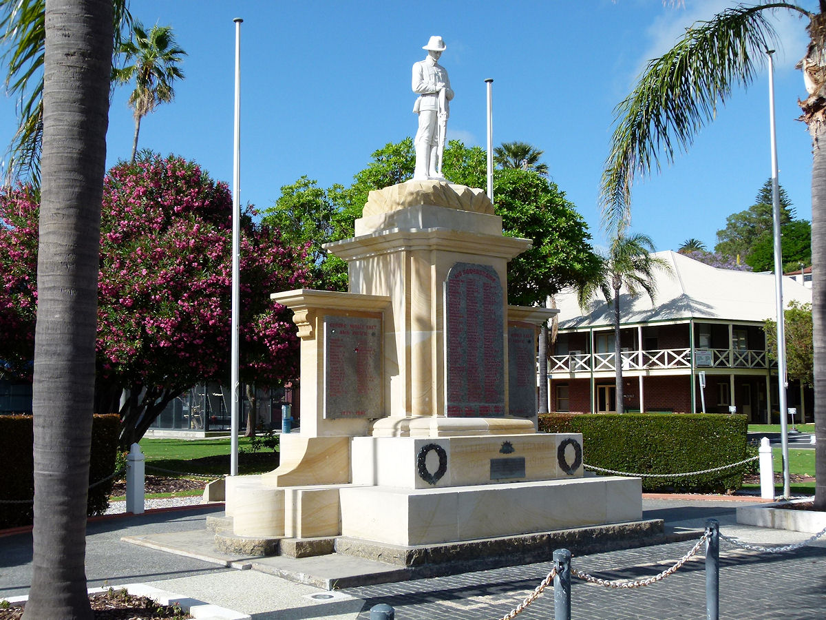 |
Bunbury - War Memorial On Stirling Street is ANZAC Park which includes the Garden of Peace and the Bunbury War Memorial. This Memorial was unveiled on November 11th, 1924 by Colonel N. M. Brazier. December 2016. Photos Ref: BUNB007 |
||
 |
Bunbury - Post Office The current Bunbury Post Office on the corner of Stirling and Victoria Streets. This opened in 1970. The former post office, a two-storey brick building on Stephen Street, was demolished after being occupied by the Crown Law Department for just a few years after the post office moved, whilst its own court accommodation was being sorted out. December 2016. Photos Ref: BUNB008 |
||
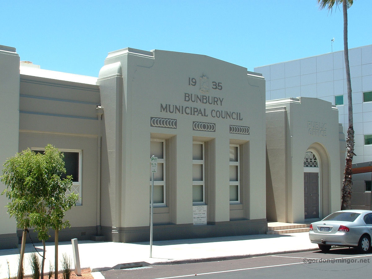 |
Bunbury - Municipal Offices on Stephen Street The Bunbury Municipal Offices on Stephen Street built in 1936. The original (1896) Bunbury Council Chambers was also on Stephen Street. Just down the road were the old courthouse (1906) and post office (1894) buildings. In 1970 the court offices moved into the post office as the post office went to new premises on the corner of Victoria and Stirling Streets. Both the old courthouse and post office buildings have since been demolished. December 2009. Photos Ref: BUNB009 |
||
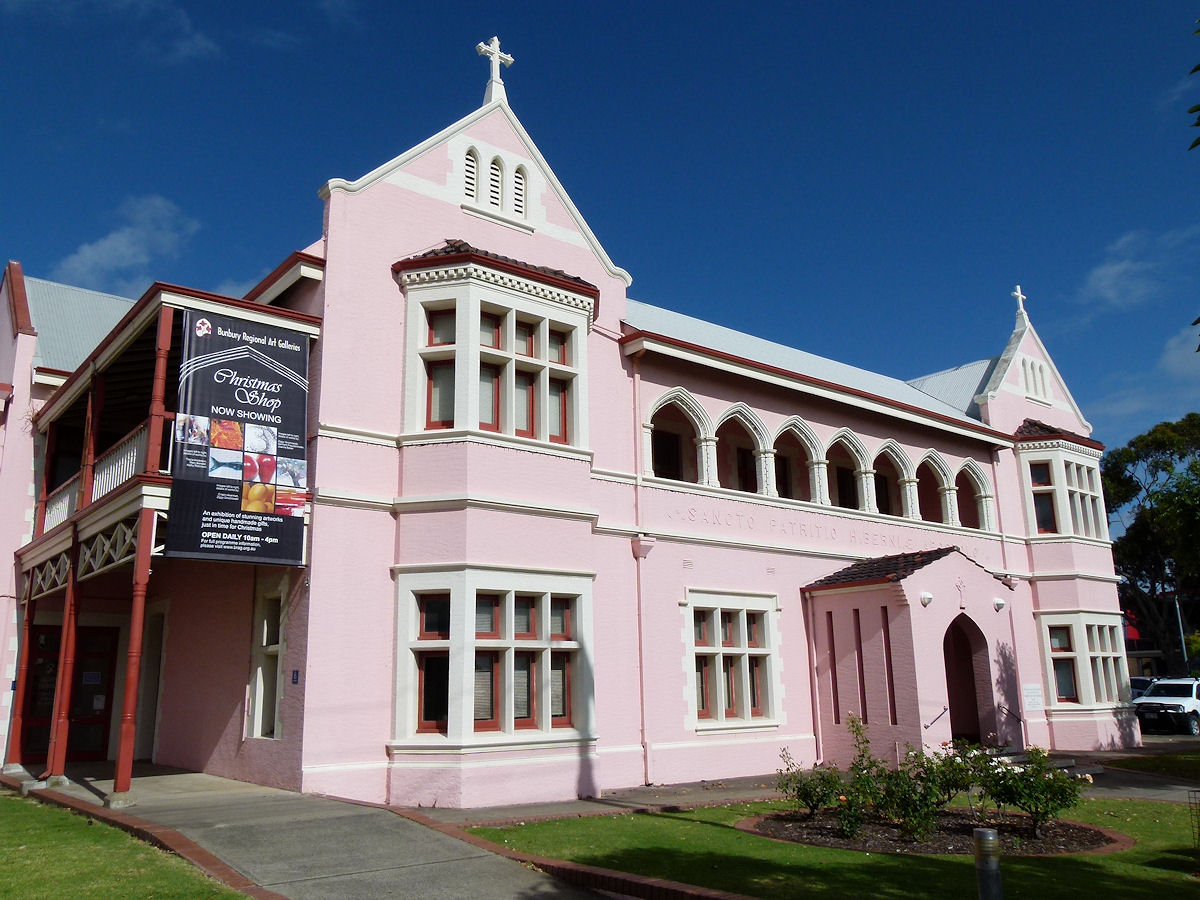 |
Bunbury - Old Convent on Wittenoom Street On Wittenoom Street this rather attractive pink building has been the Bunbury Regional Art Gallery since 1987. This building was formerly the Convent of Mercy and was opened in 1897. December 2016. Photos Ref: BUNB010 |
||
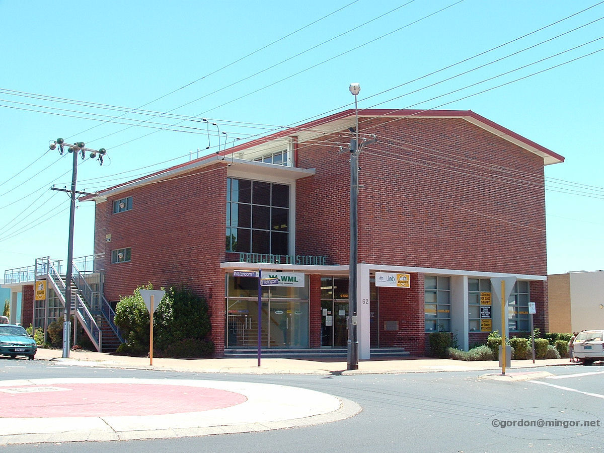 |
Bunbury - Railway Institute The Railway Institute building on Wittenoom Street. Not so many rail workers in town now, I guess. No more Bunbury loco and a Bunbury winter morning with the whole town centre shrouded in stream train coal smoke mixed with fog. The first Railway Institute building was on Arthur Street and was built in 1905. The pictured building was erected in 1956. December 2009. Photos Ref: BUNB011 |
||
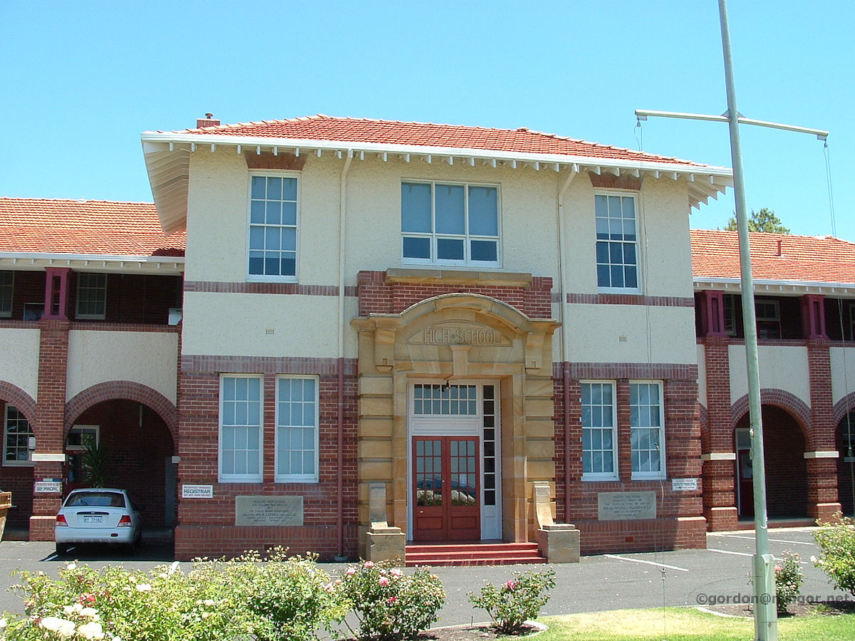 |
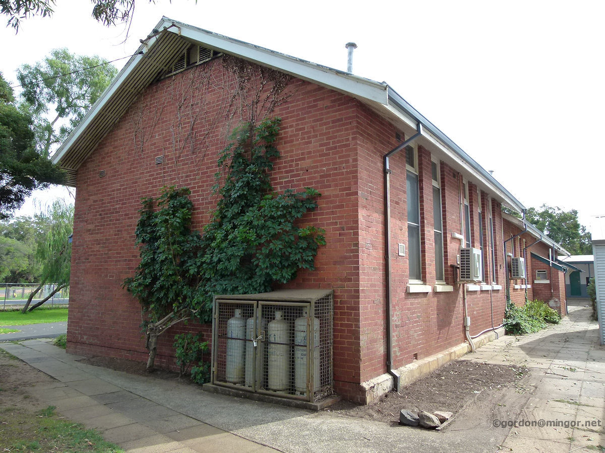
Bunbury - High School Bunbury Senior High School sits just up and over Boulter's Heights. Each morning a stiff walk up the hill for the students. This is the front of the school. Construction commenced in 1922 with many later additions being made across the decades. December 2009. Photos Ref: BUNB012 |
||
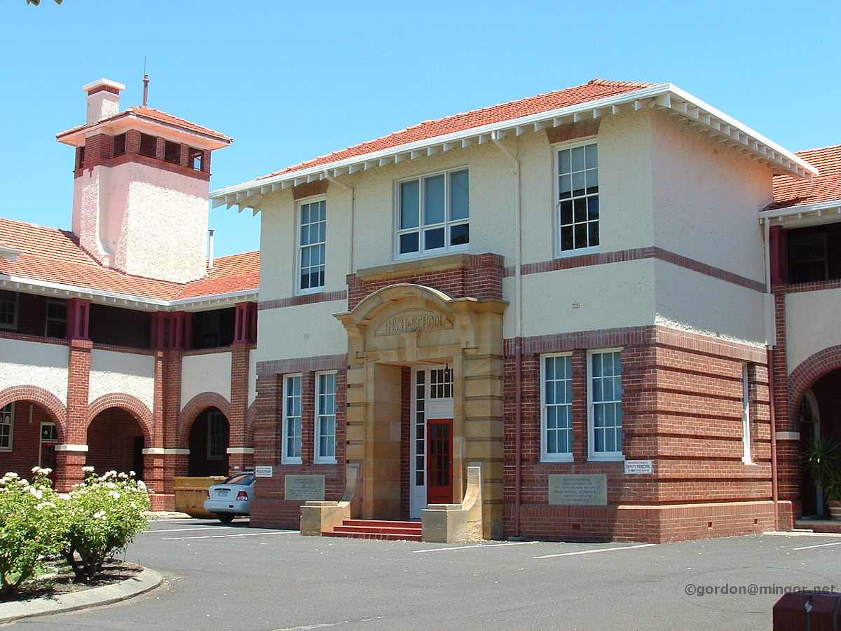 |
Bunbury - High School Another view of the front of the school. Apparently the front of the school is heritage listed. This section would be part of the first built in 1922 - 1923. December 2009. Photos Ref: BUNB013 |
||
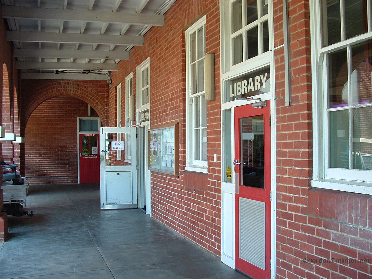 |
Bunbury - High School In the above photo, that wing on the lower floor on the right houses the school library. It did 45 years ago and still does today. Here is the front of the library. December 2009. Photos Ref: BUNB014 |
||
 |
Bunbury - High School Viewed from the 'beach' side of the school, here is the rear and part of the sports oval. December 2009. Photos Ref: BUNB015 |
||
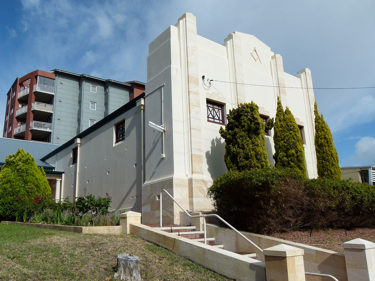 |
Bunbury - Masonic Lodge On Wittenoom Street is the Masonic Wellington Lodge. This was built in 1893. The Lodge was formed on May 10th, 1886. December 2016. Photos Ref: BUNB016 |
||
 |
Bunbury - ABC Studio On Wittenoom Street this is the current home of ABC broadcasting in Bunbury. This building used to look much the same in the mid-late 1960's when it housed the 6TZ-CI radio station. Some 6TZ DJ's from those days were Norm Bain, Colin Wholagan, Kim White, Mike Warren and Peter Bandy. School kids like me were welcome into the studio. The building was rebuilt after a nearby construction crane fell on it during a severe storm on May 16th, 2005. December 2009. Photos Ref: BUNB017 |
||
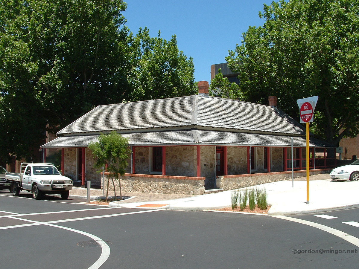 |
Bunbury - Old Government Building This lovely old building (corner Stephen and Wittenoom Streets) has been renovated and restored. It started out as Bunbury's first post office (1864 - 1894) then afterwards it was the home to some government offices including the bailiff's office and a Police annex. The building was erected in 1864. December 2009. Photos Ref: BUNB018 |
||
 |
Bunbury - Boulter's Menswear Boulter's Menswear has been here since 1923. Mr Alfred Boulter caused this to be built. It's on the corner of Stephen Street and Victoria Street. And it still looks to be going strong. 'Mercer', on the top, front of the building simply indicates that this business sells (or sold) textile fabrics and other fine materials. April 2013. Photos Ref: BUNB019 |
||
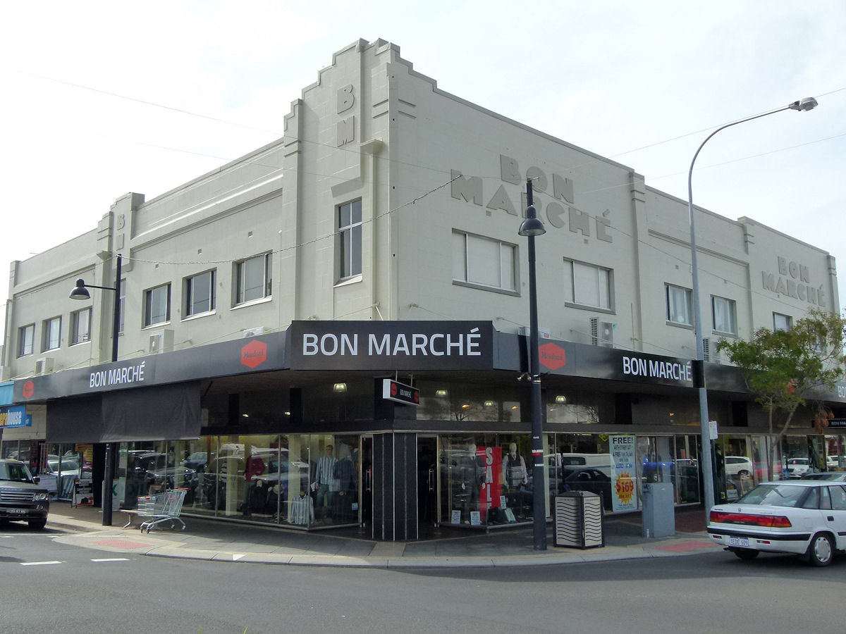 |
Bunbury - Bon Marche Still on the corner of Stephen and Victoria Streets is the Bon Marche store building which I think used to predominantly retail Manchester. It looks that this may now be a part of the Mensland chain of stores. The store opened in 1891 and was constructed by Mr William Spencer, who also built the Swan Inn (later known as the Wellington Hotel). Mr Spencer was one time Mayor of Bunbury and later MLC for the South Western Province. April 2013. Photos Ref: BUNB020 |
||
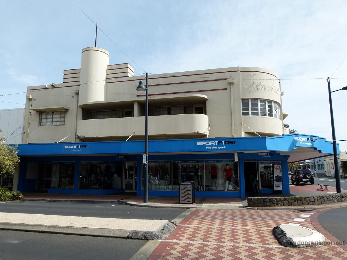 |
Bunbury - Cronshaws A little further north along Victoria Street is the old Smith's Buildings, constructed in 1937. This was the home of Cronshaws for many decades. Who can remember treading the creaky, wooden floorboards with their mother whilst she hunted for children's clothing bargains? This building is currently occupied by Sports First. April 2013. Photos Ref: BUNB021 |
||
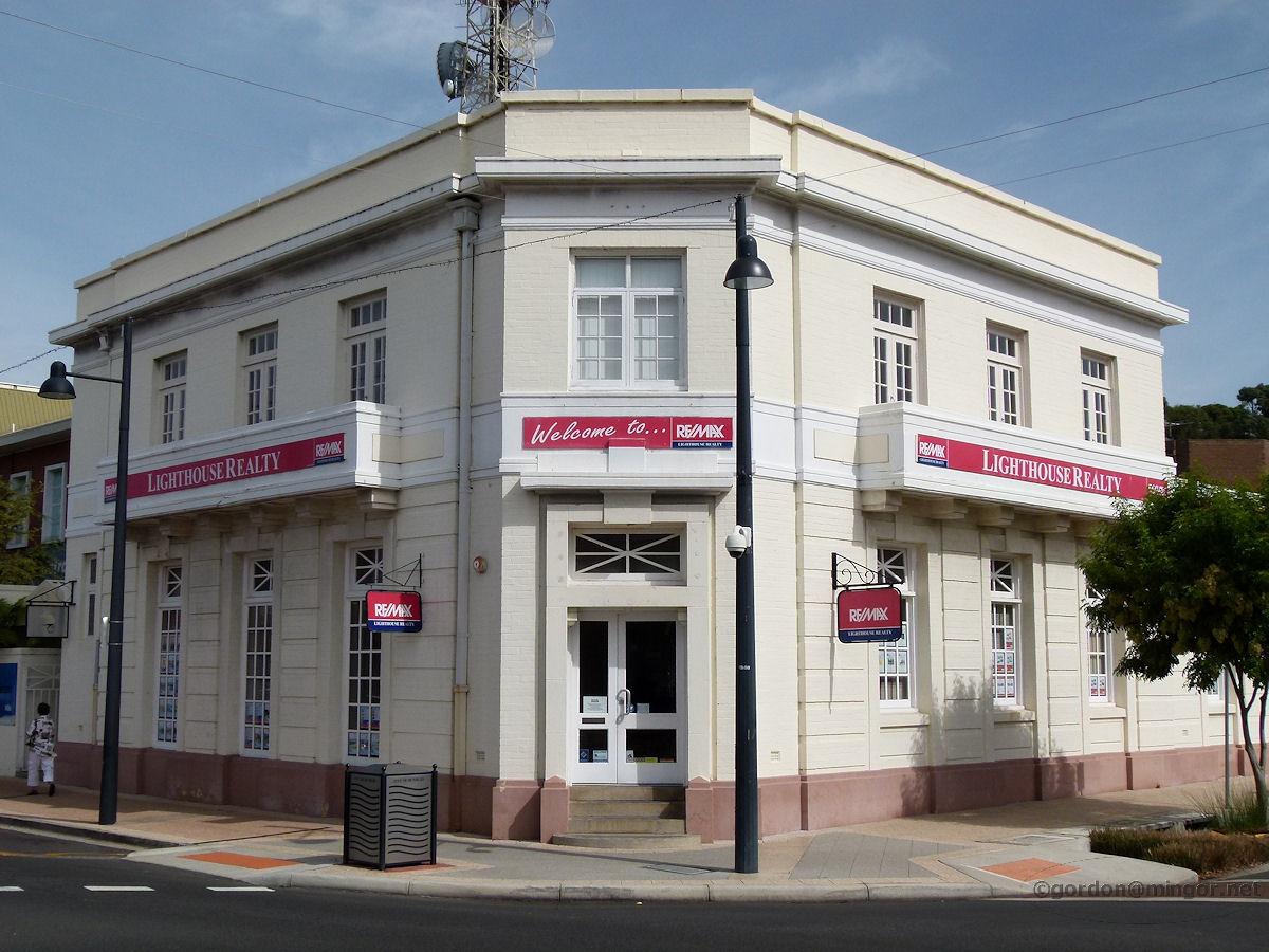 |
Bunbury - Old Commonwealth Bank On a corner of Stephen and Victoria Streets, this building was the Commonwealth Bank up until the early 1970's when they moved to their brand new premises further down Stephen Street (the old Mayfair Theatre was demolished and a new bank was built on that site). Lighthouse Realty has its business in the pictured building now. The building was constructed in 1929. April 2013. Photos Ref: BUNB022 |
||
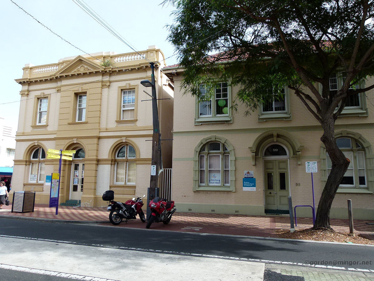 |
Bunbury - Old Western Australian Bank The building on the left is the former Western Australia Bank. It was constructed in 1896. It seems that this building, together with its neighbour on the right at number 99, join as Bunbury Lotteries House. April 2013. Photos Ref: BUNB023 |
||
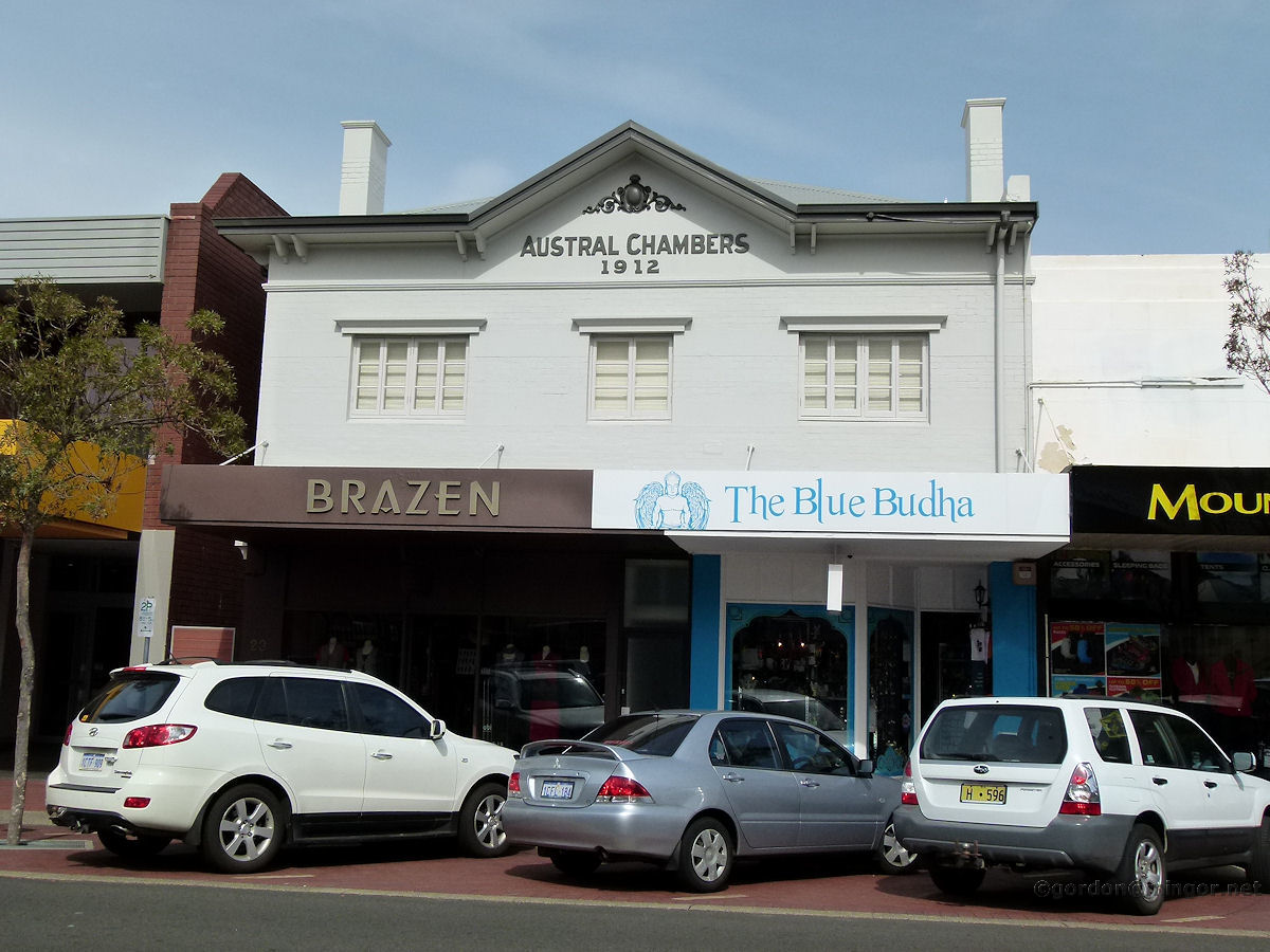 |
Bunbury - Austral Chambers On Stephen Street is Austral Chambers, constructed in 1912. This day home to Brazen and The Blue Budha. When I was here in the 1960's this was the Mayfair Tearooms. Next door (to the left) was the Mayfair Theatre built in 1937 on the site of the old Princess Theatre. The Mayfair Theatre was demolished in the early 1970's to make way for a new Commonwealth Bank building. After the theatre closed but obviously before demolition, Boans (formerly Haywards) used the building as part of their department store. April 2013. Photos Ref: BUNB024 |
||
 |
Bunbury - Bills Furniture On Victoria Street this old building caught my eye. Bill's Furniture is obviously here now but the design of the building is reminiscent of perhaps a theatre of sorts? And so it was. This used to be the Lyric Theatre and it was built in 1905. April 2013. Photos Ref: BUNB025 |
||
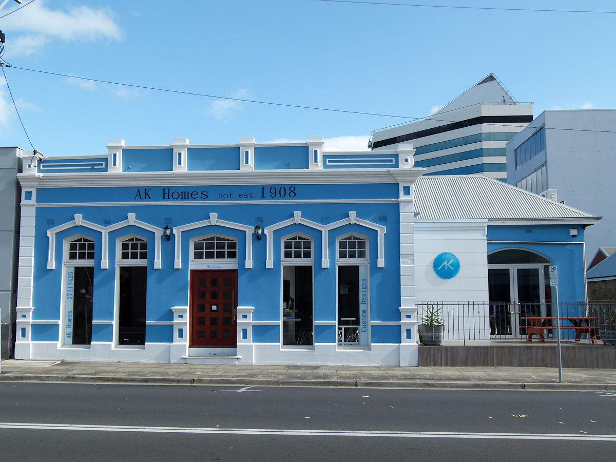 |
Bunbury - AK Homes Building This building at 32 Wellington Street is clearly old and looks very attractive in the blue and white paintwork. The sign at the top of the building might confuse any budding historians. At least it's honest. December 2016. Photos Ref: BUNB026 |
||
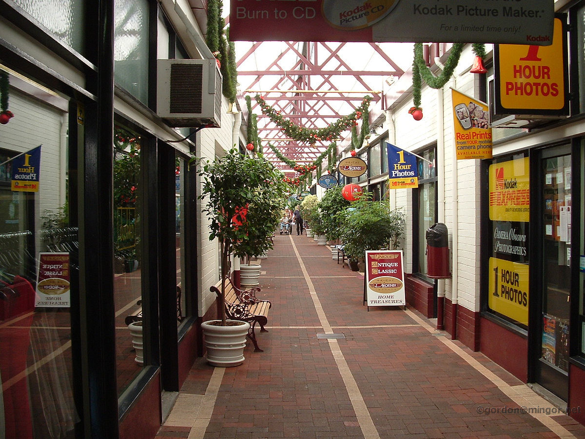 |
Bunbury - Central Arcade Central Arcade running off Stephen Street west to Princep Street. This view is looking west. An original survivor is Gomm's shoe shop up the distant end. Other shops come and go. Gomm's has been here since the arcade was built in the 1960's. December 2009. Photos Ref: BUNB027 |
||
 |
Bunbury - Paisley Centre on Arthur Street On Arthur Street is the Paisley Centre. Behind here used to be the railway yards with an overhead pedestrian bridge. We used to walk over the bridge and get smoked out by steam locomotives passing beneath. This place was originally the Bunbury Boy's School built in 1886. It became the Bunbury Public School in 1895 and operated thus until 1961. In the late 1960's this was a technical school. Later it became a dance studio. Chequered history. The other classrooms which were off to the right seem to have been demolished. April 2013. Photos Ref: BUNB028 |
||
 |
Bunbury - View Towards Port A view from Boulter's Heights. This is looking past the Bunbury Tower on the right of picture towards the old harbour area. December 2009. Photos Ref: BUNB029 |
||
 |
Bunbury - Tower Part way going up Boulter's Heights, here is a view of the northern-ish end of town featuring the Bunbury Office Tower and the Lord Forrest Hotel just to the left of the tower. December 2010. Photos Ref: BUNB030 |
||
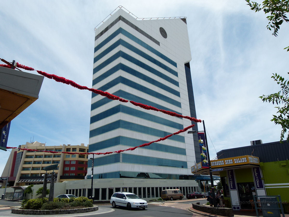 |
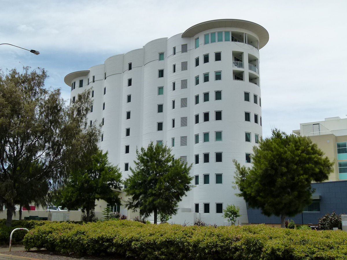
Bunbury - Tower The Bunbury Office Tower viewed from Victoria Street right in town. The tower opened in December 1986. December 2010. Photos Ref: BUNB031 |
||
 |
Bunbury - Lord Forrest Hotel The Lord Forrest Hotel was opened in August, 1986. It's on Symmons Street, just off Victoria Street, down towards the Burlington Hotel. December 2010. Photos Ref: BUNB032 |
||
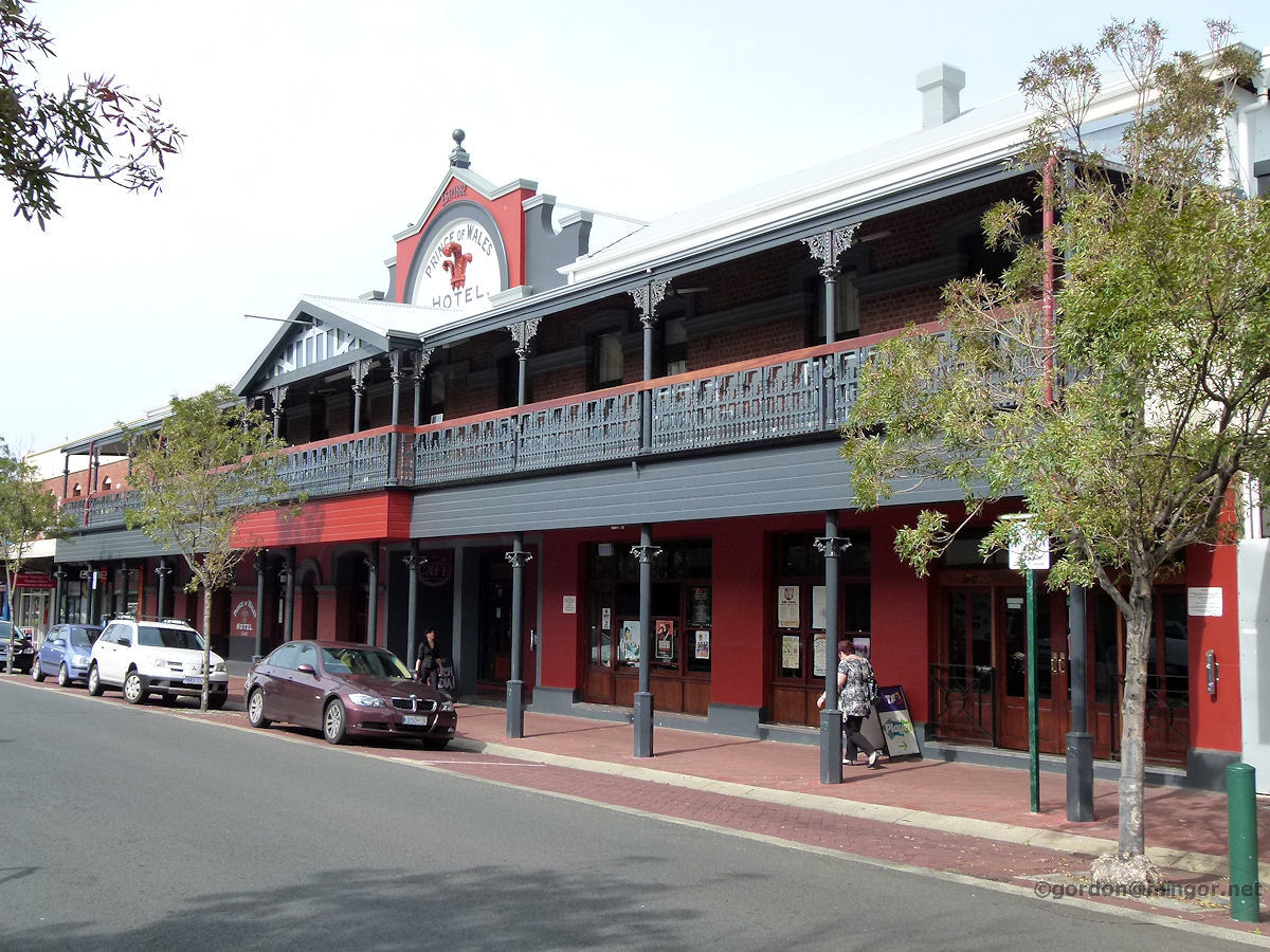 |
Bunbury - Prince of Wales Hotel The Prince of Wales Hotel sits on Stephen Street. The hotel was constructed in 1882. April 2013. Photos Ref: BUNB033 |
||
 |
Bunbury - Burlington Hotel The Burlington Hotel on Victoria Street. Once the most popular pub in town with its live music. "Be Early at the Burly". The hotel was erected in 1899. December 2009. Photos Ref: BUNB034 |
||
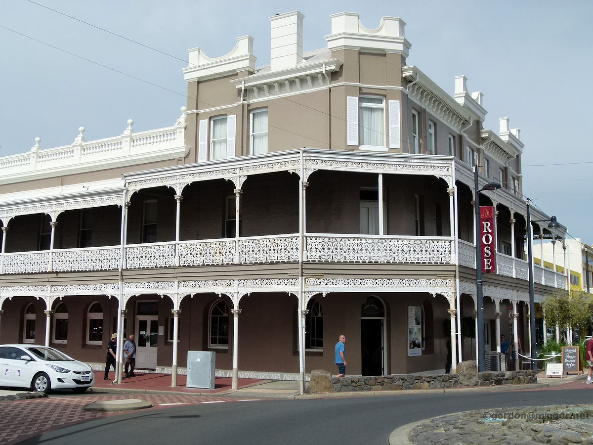 |
Bunbury - Rose Hotel The Rose Hotel with its ornate lattice work is an outstanding landmark on the corner of Victoria and Princep Streets. The original hotel, a wooden structure, was built in 1865 by Samuel Rose. In 1897 Mr Illingsworth virtually rebuilt the hotel to look much as it does today. In the 1970's Mr Drinkwater purchased the hotel. April 2013. Photos Ref: BUNB035 |
||
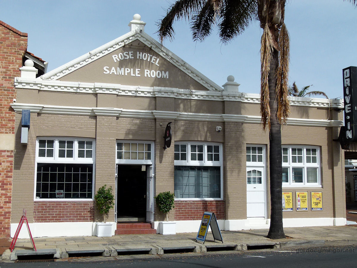 |
Bunbury - Rose Hotel Sample Room Further down Princep Street is the Rose Hotel's Sample Room which serves now as a bottle shop. This was built in 1904 as part of general hotel modifications. A Sample Room was a spacious accommodation unit rented to travelling salesmen as a place to stay and also as a place to display their wares. April 2013. Photos Ref: BUNB036 |
||
 |
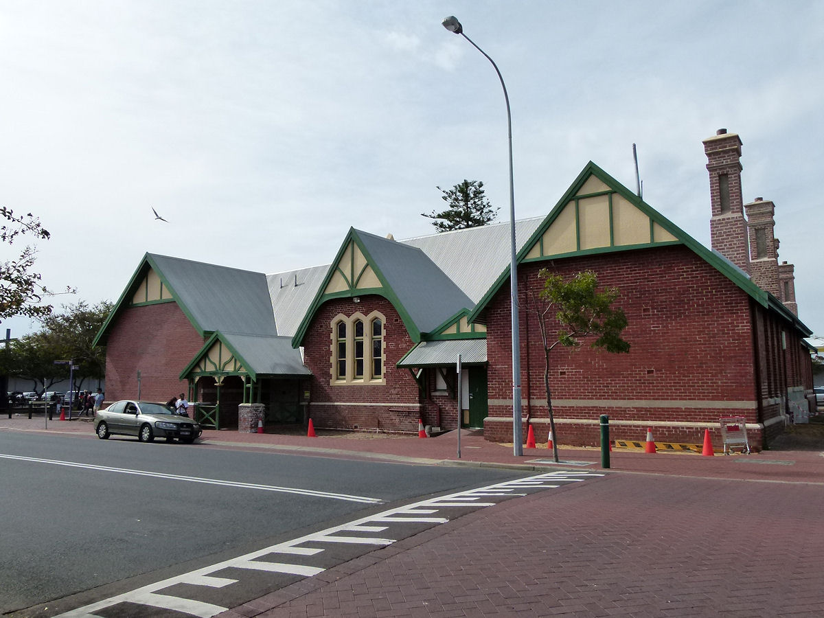
Bunbury - Old Railway Station This is the old railway station in the town centre. The track doesn't go as far as this now but the old building remains. This is the 'track' side of the station. The first railway station was built here in 1894. This was made of wood and burnt down in 1904. The pictured building is made of brick and was erected in 1905. December 2009. Photos Ref: BUNB037 |
||
 |
Bunbury - Old Railway Station Again the old railway station on the 'track' side. Up this end is an Internet Cafe. On the other side is where you catch/alight from the local bus connecting to the new South Bunbury station. To the left was once an extensive rail yard and locomotive depot. Rail lines ran north up the land-backed wharf and old timber shipping jetty. A single track ran over the Stirling Street railway crossing and on to Picton. All surrounding rail lines have been lifted and the loco depot has been removed. December 2009. Photos Ref: BUNB038 |
||
 |
Bunbury - Music Shell Adjacent to the old Bunbury rail station is the fairly recently constructed Graham Bricknell Memorial Music Shell. Off to the right you can see the office tower. April 2013. Photos Ref: BUNB039 |
||
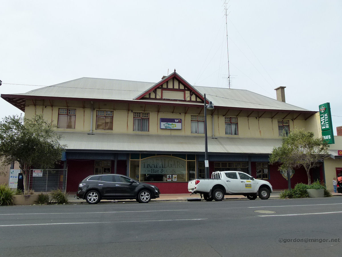 |
Bunbury - Trafalgars On this site in 1857 Mr William Spencer built the Swan Inn which was later to become known as the Wellington Hotel. Mr Spencer lived in the hotel until circa 1871. An event occurred in 1918 which might have resulted in a total building reconstruction or just a structural re-modelling. Approximately mid-1980's the hotel was re-badged as Trafalgar's Bar and Cafe. The hotel is on the north side of Victoria Street, close to the Burlington Hotel. April 2013. Photos Ref: BUNB040 |
||
 |
Bunbury - Reef Hotel At one time the Captain Bunbury Hotel was the last building on Victoria Street heading north towards the port. Just past here was Guppy Park. An hotel was constructed on this site in 1890 and was then known as Gordon's Hotel. This hotel is recorded as being a re-construction so it seems the older hotel was demolished to make way for this building. Signage proclaims this is now the Reef Hotel. April 2013. Photos Ref: BUNB041 (Demolished in June 2016 due to extensive fire damage in a Jan 2016 fire) |
||
 |
Bunbury - Wheat Silo Apartments In the old days these buildings where a uniform grey and forbidding-looking wheat silos. The wheat was trained in, stored and eventually shipped out through the adjacent port. Rather than simply bulldoze the silos when their original purpose ended, some were left standing and converted into these apartments. The silos were built in 1937. The building still looks not very attractive and forbidding to me. December 2010. Photos Ref: BUNB042 |
||
 |
Bunbury - St Boniface Anglican Cathedral St Boniface Anglican Cathedral sits high upon its hill overlooking Spencer Street. It was built in 1961. April 2013. Photos Ref: BUNB043 |
||
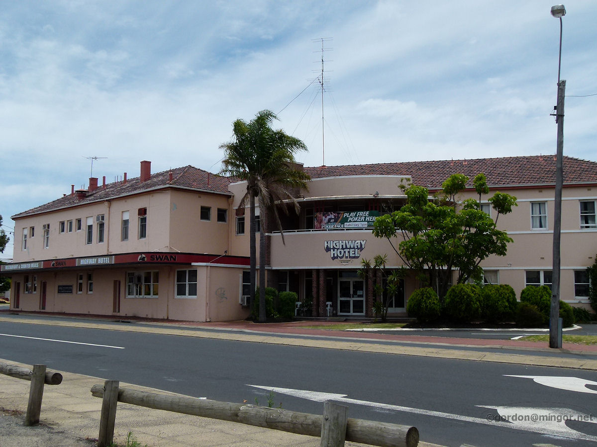 |
Bunbury - Highway Hotel On the corner of Forrest Avenue and Spencer Street stands the Highway Hotel. The hotel recently celebrated it's 116th anniversary which puts its origin date around 1898. It looks younger than that. The hotel enjoyed renovations in 2011. December 2010. Photos Ref: BUNB044 |
||
 |
Bunbury - Leschenault Quays on Austral Parade This building is the Leschenault Quays, a shopping centre on the corner of Austral Parade and King Road. December 2010. Photos Ref: BUNB045 |
||
 |
Bunbury - Parade Hotel The Parade Hotel hasn't changed much in decades. The outside is rather unimaginative but I recall the inside being quite palatable, especially the rear beer garden next to the estuary. The hotel was constructed in 1897. December 2010. Photos Ref: BUNB046 |
||
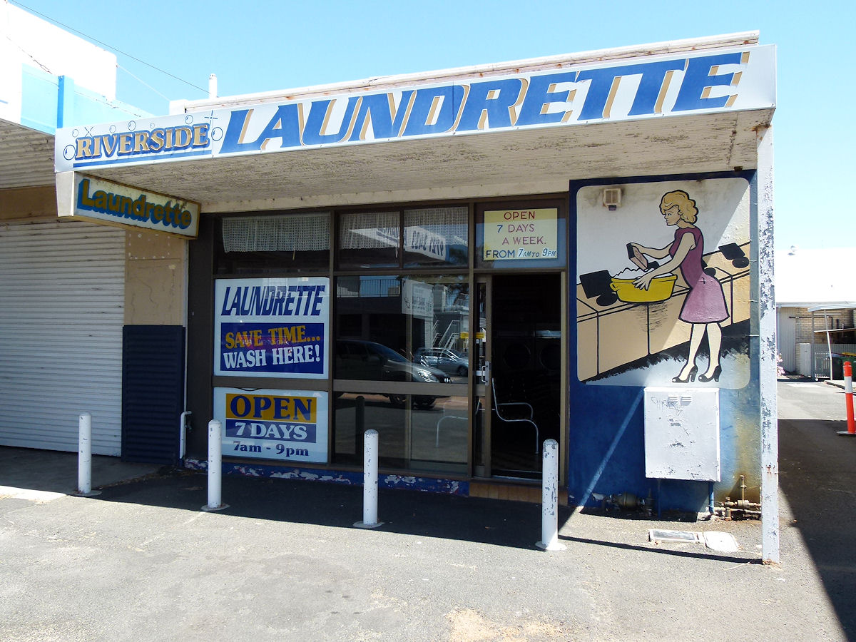 |
Bunbury - Riverside Laundry Over the road from the Parade Hotel is the Riverside Laundrette. I feel sure that this was once Riverside Butcher's, owned and operated by Lance and Violet Kershaw. Fond memories. December 2018. Photos Ref: BUNB047 (January 2025. I have been advised that this building has been demolished) |
||
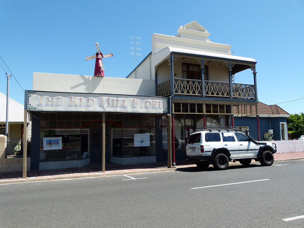 |
Bunbury - Red Mill Store At 59-61 Stirling Street in the area that is known as East Bunbury, or Rathmines, is the Red Mill Store and adjacent building. The buildings were built in 1898. The upper floor was added to the building on the right in 1927. Back in those days proprietors Thomas Chadd and Benjamin Whitty used the premises as a general store and bakery. These days the place looks like an art studio. December 2018. Photos Ref: BUNB048 |
||
 |
Bunbury - East Bunbury Church of Christ The Church of Christ at 74 Austral Parade, East Bunbury. This was built around 1920 as St Patrick's Anglican Church. At another time this was a Greek Orthodox Church. The Rathmines War Memorial sits close by, next to the road. December 2018. Photos Ref: BUNB049 |
||
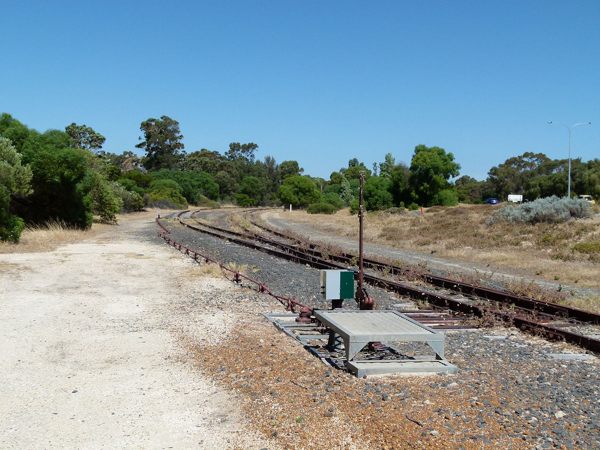 |
Bunbury - Power House Railway Lines The Bunbury Power House stood on Koombana Bay around where the new port is now, perhaps a little further north. When operational coal was railed up to the power station via the land bridge near the old loco depot. Much of the old rail has gone but this last stretch still remains. This would just just slightly south of where the power station was. December 2018. Photos Ref: BUNB050 |
||
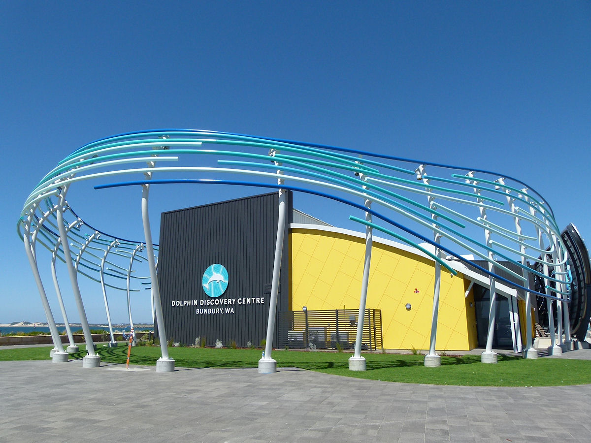 |
Bunbury - Dolphin Centre The Bunbury Dolphin Centre in Koombana Park. This land used to be where the power house railway ran. December 2018. Photos Ref: BUNB051 |
||
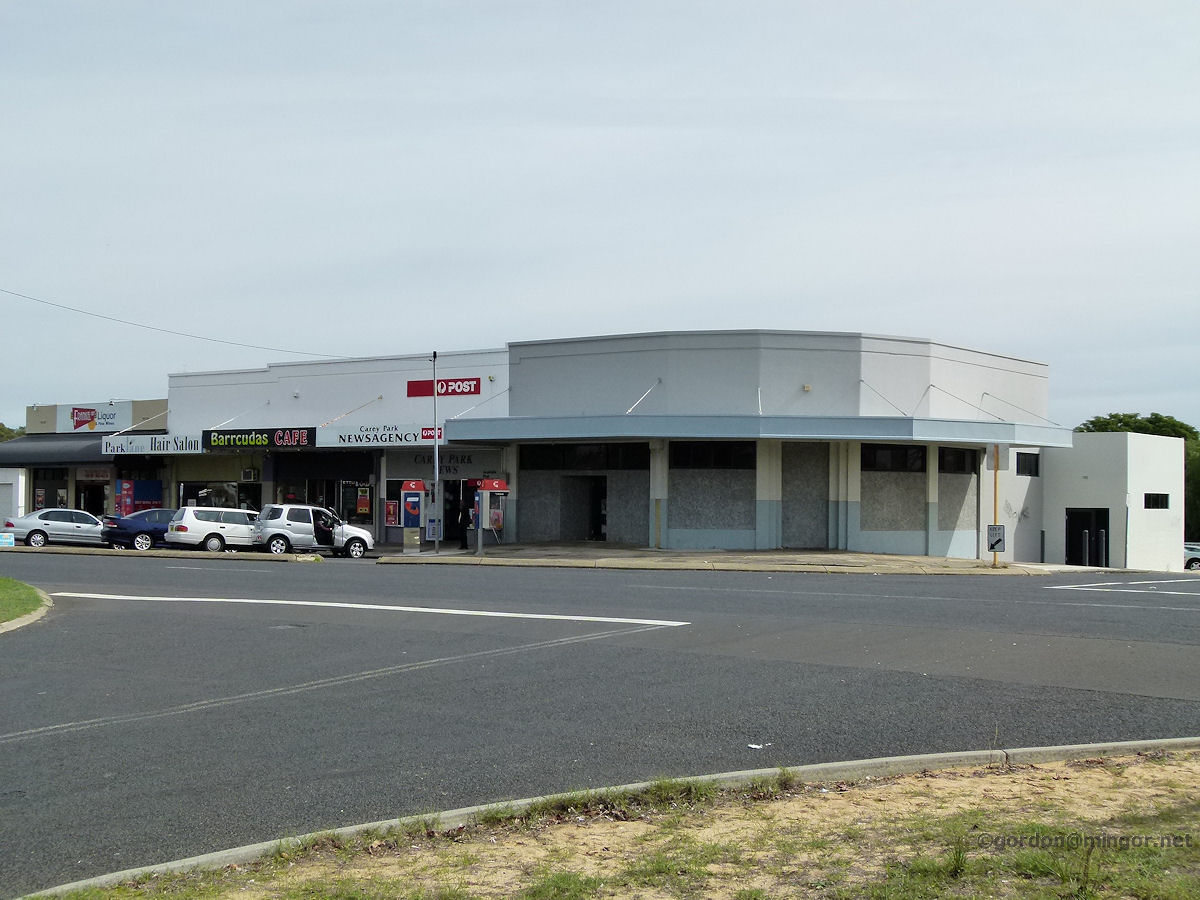 |
Bunbury - Frankel Street Shops These are the shops on Frankel Street in Carey Park. Carey Park was developed mostly by the (then) State Housing Commission in the early 1960's and houses were predominantly made of asbestos sheeting with tiled roofs. These were budget homes occupied under rent or rent/buy schemes. Many houses still look the same today after around 50 years. Little modernization or re-development is evident in the area. That blocked up shop centre/right was the local grocery store years ago. April 2013. Photos Ref: BUNB052 |
||
 |
Bunbury - Forrest Park In Forrest Park is a miniature rail system very like that at Castledare in Bentley, a Perth suburb. This building, Forrest Station, is actually the original Capel railway station building. April 2013. Photos Ref: BUNB053 |
||
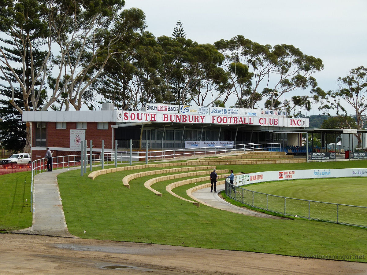 |
Bunbury - Hands Memorial Oval The J. E. Hands Memorial Oval has been the home of football club South Bunbury for decades. Here are their club rooms. Years ago spectators would drive their cars into the ground and watch the game from the comfort of their EH Holdens (or XR Falcons, Valiants, and the like). April 2013. Photos Ref: BUNB054 |
||
 |
Bunbury - Picton School Out near Picton on Vittoria Road is the old Picton School. Here is one of the older buildings on this site. The school is now Bunbury John Calvin School. The original Picton School was located on the other side of the highway. Nothing now remains of the original school. April 2013. Photos Ref: BUNB055 |
||
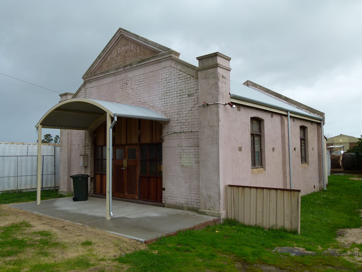 |
Bunbury - Picton Hall The Picton Agricultural Hall on the South Western Highway, across from the superphosphate works. Construction of the hall was proposed by a group Glen Iris settlers at a meeting on the proposed site in May 1904. The meeting was documented at length in an issue of the Waterloo Gazette in 1904. July 2014. Photos Ref: BUNB056 |
||
 |
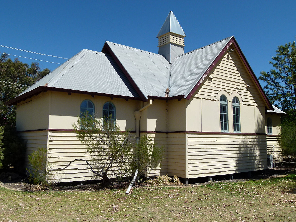
Bunbury - Old Picton Church The Old Picton Church on Wollaston Crescent. One of the new bypasses cuts off eastern access and housing has encroached on church land on most sides. I recall a couple of large Moreton Bay figs here which have gone. The church was difficult to find due to lack of signposts. This is St Mark's Anglican Church of the Parish of Carey Park. It was built in 1842 by John Wollaston who was then First Chaplain of Port Leschenault. April 2013. Photos Ref: BUNB057 |
||
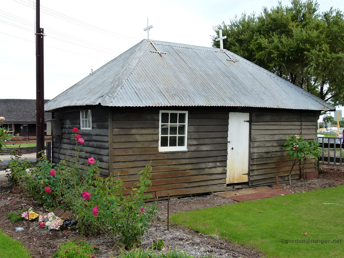 |
Bunbury - Australind St Nicholas Church In Australind is St Nicholas' Church which is reputed to be the smallest church in Australia. It was constructed in 1848 originally as a worker's cottage. The church is currently undergoing some kind of internal renovation so the inside is bare. This is a view from the rear taking in the lawn and memorial rose garden. April 2013. Photos Ref: BUNB058 |
||
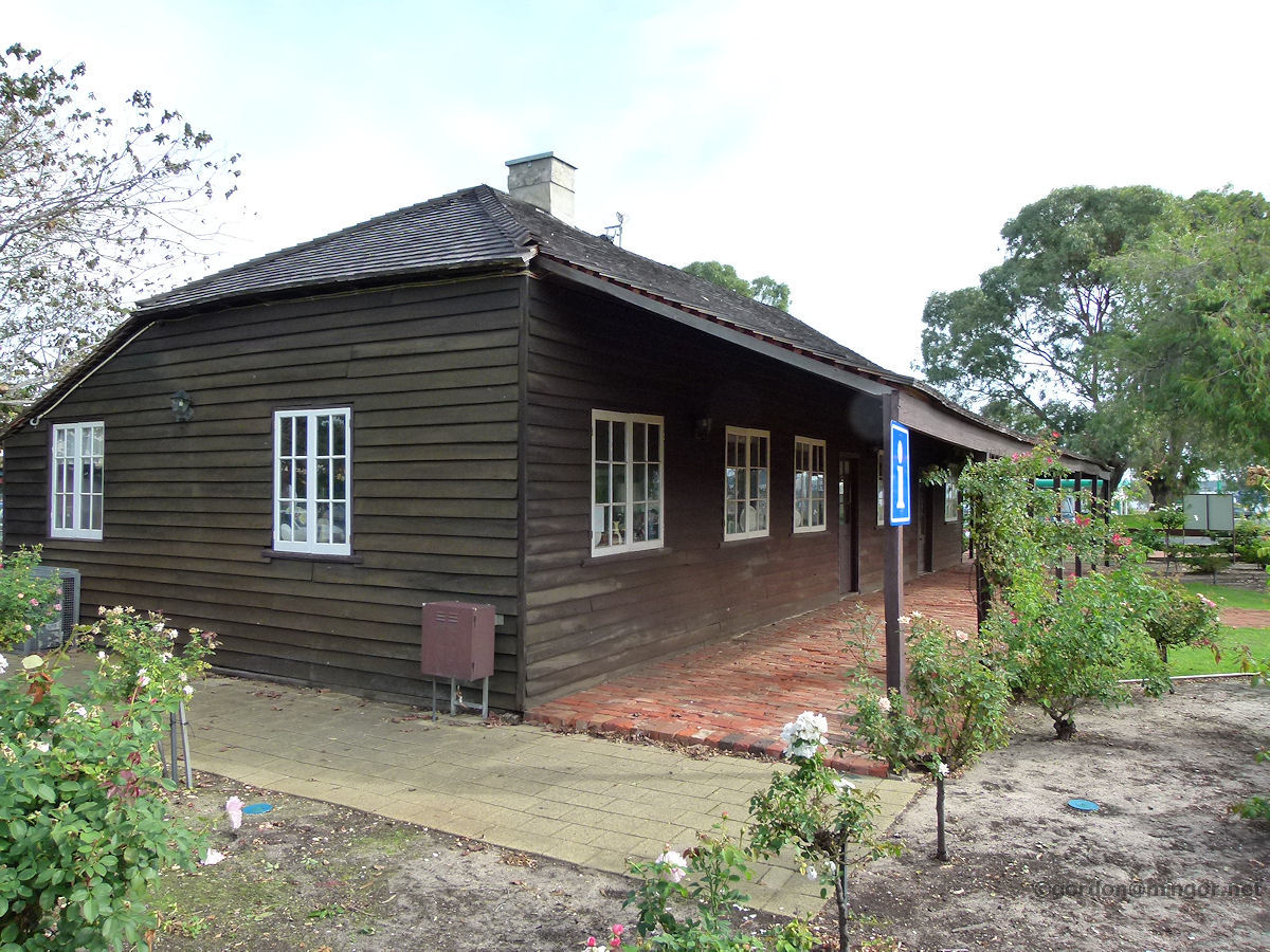 |
Bunbury - Australind Henton Cottage Henton Cottage is across the road from St Nicholas Church and pre-dates it by some seven years. It is said that this was the first hotel in the Bunbury district. The cottage is currently used as a bric-a-brac store and it is stocked with lots of tempting merchandise. April 2013. Photos Ref: BUNB059 |
||
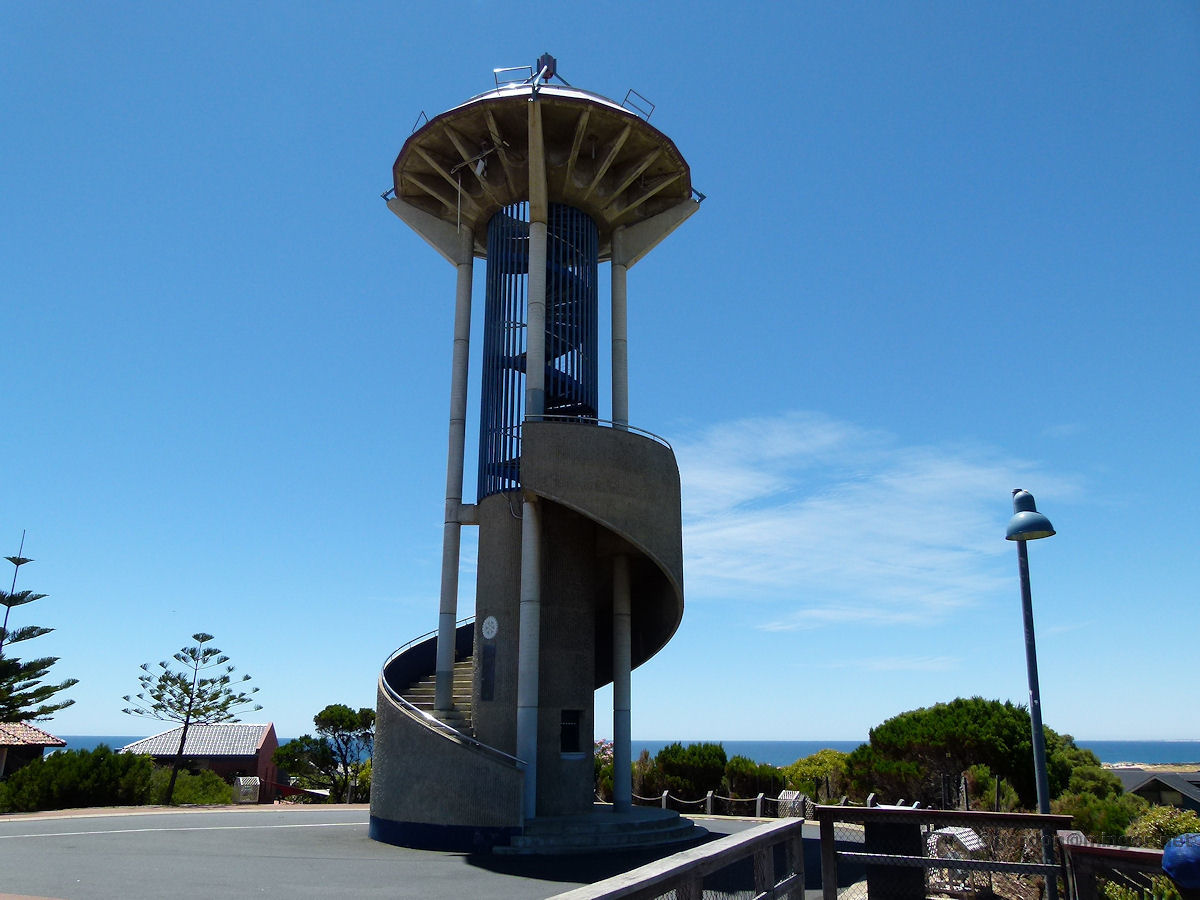 |
Bunbury - Apex Lookout The Apex Lookout atop Marlston Hill overlooks Bunbury. The lookout was built in 1988. Previously on this site was the original lighthouse. The new Casuarina Lighthouse stands at 25 metres and is located a short distance away near where once were BP fuel storage tanks. December 2013. Photos Ref: BUNB060 |
||
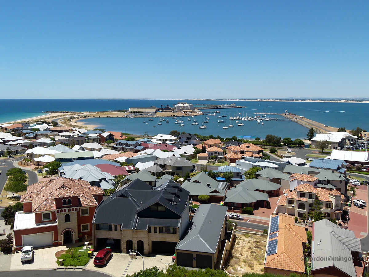 |
Bunbury - Apex Lookout Climbing up to the top of the Apex Lookout, here is a series of photos taken from this high vantage point. This one looks across to the old harbour. The wooden shipping jetty has now gone. The houses in the foreground make up a new development. December 2013. Photos Ref: BUNB061 |
||
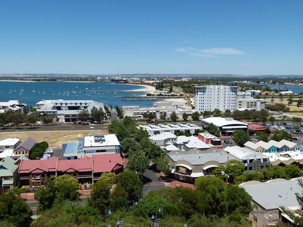 |
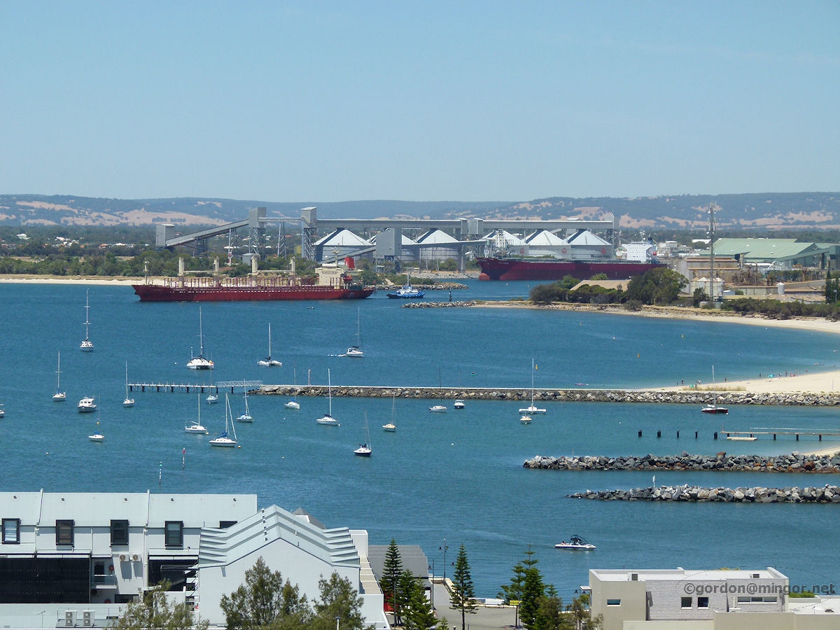
Bunbury - Apex Lookout Looking east taking in the re-modelled former wheat silos and across onto Koombana Island. December 2013. Photos Ref: BUNB062 |
||
 |
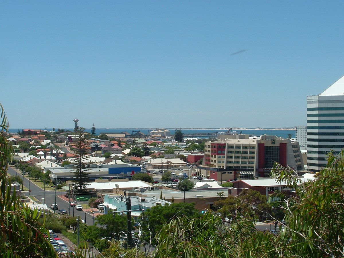
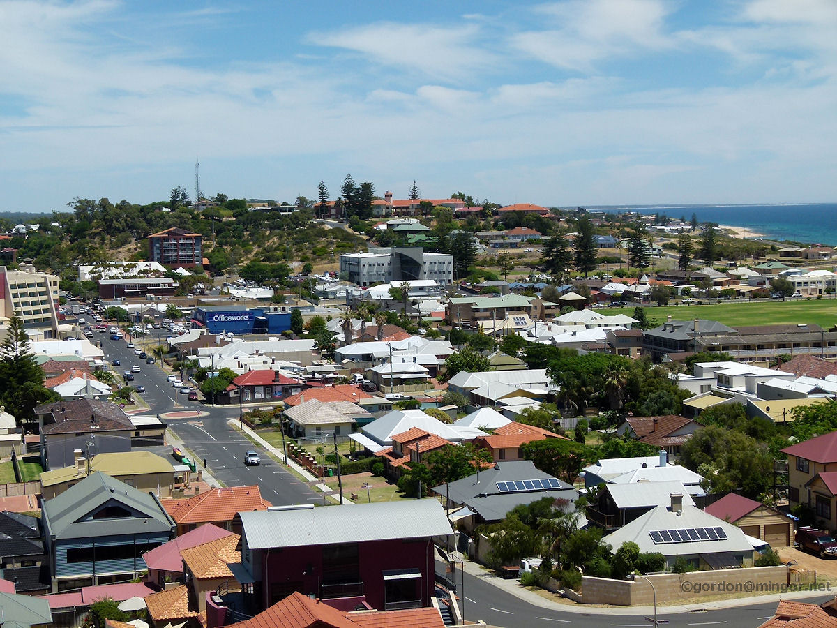
Bunbury - Apex Lookout Moving slightly south-east from the above picture, you can still see the old wheat silos to the left. The street running in the foreground is Victoria Street. The former Bunbury Hotel is the dark brown building, centre and right. December 2013. Photos Ref: BUNB063 |
||
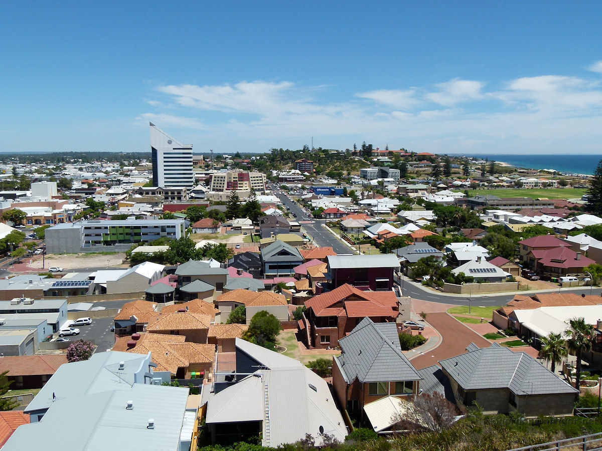 |
Bunbury - Apex Lookout The Bunbury Office Tower dominates this picture. The road running up and away is Wittenoom Street. The high school is visible atop Boulter's Heights. December 2013. Photos Ref: BUNB064 |
||
 |
Bunbury - Apex Lookout Looking out to sea. Off to the right is the Casuarina Point Lighthouse. Cape Naturaliste is visible on the horizon. A mirage effect distorts the cape image with the landmass being inverted above what is real. You can see some top sections of the image jutting back so what look like cliffs is just an optical illusion. December 2013. Photos Ref: BUNB065 |
||
 |
Bunbury - Apex Lookout A closer looks down Wittenoom Street showing the high school a little more clearly and Boulter's Heights. The land out to sea eventually curves its way around to Busselton and Geographe Bay. December 2013. Photos Ref: BUNB066 |
||
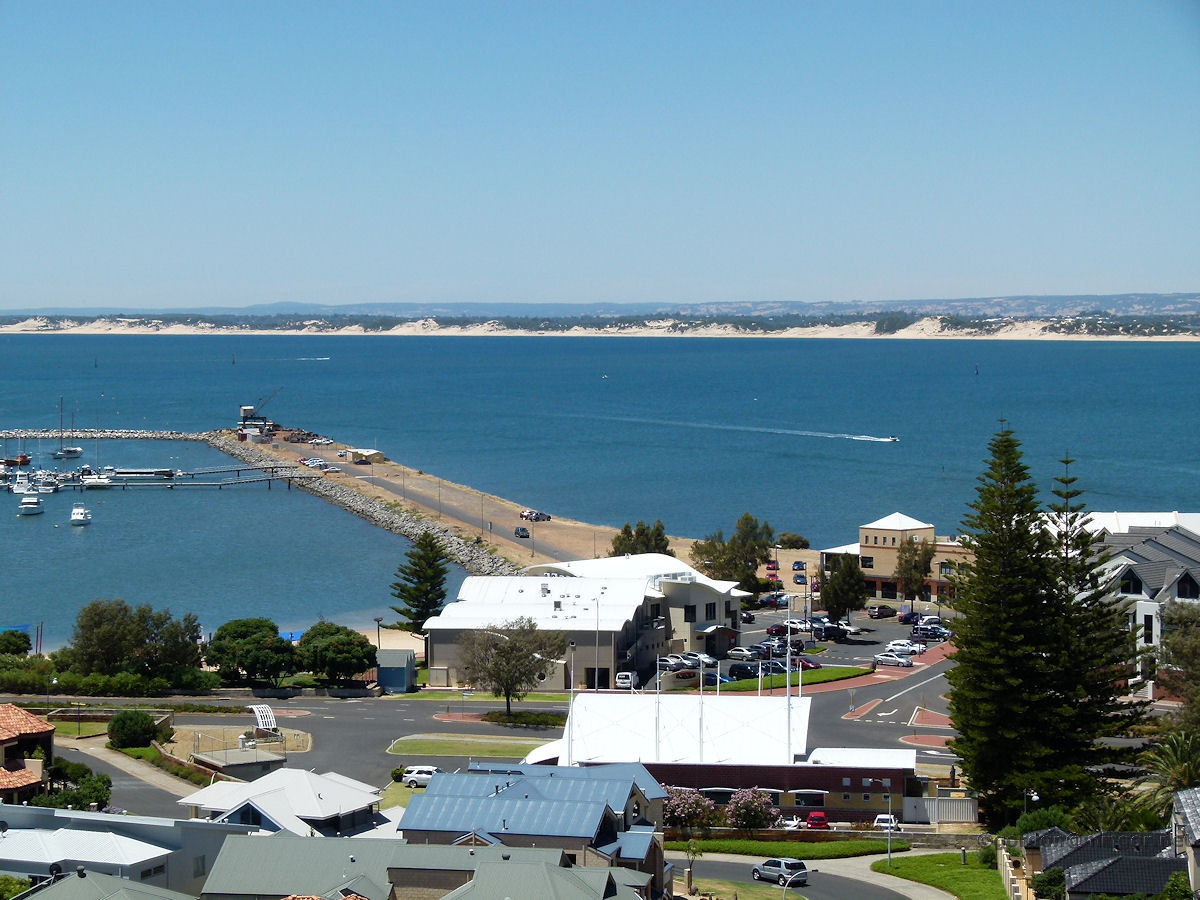 |
Bunbury - Apex Lookout Another look at part of the old harbour. The stone groyne has replaced the old wooden jetty. In the old day ships tied up here and some kids like me could actually go aboard. Children road their bikes here and cast crab nets into the water. A railway line ran up the jetty with its little shunter puffing away. A store was at the start of the jetty selling ice creams, drink and bait. There was even a phone box there. Great place for kids back then. December 2013. Photos Ref: BUNB067 |
||
 |
Bunbury - Apex Lookout A ship leaves the new inner harbour. In the foreground, right, are rocks forming a channel through into the Leschenault Estuary. December 2013. Photos Ref: BUNB068 |
||
 |
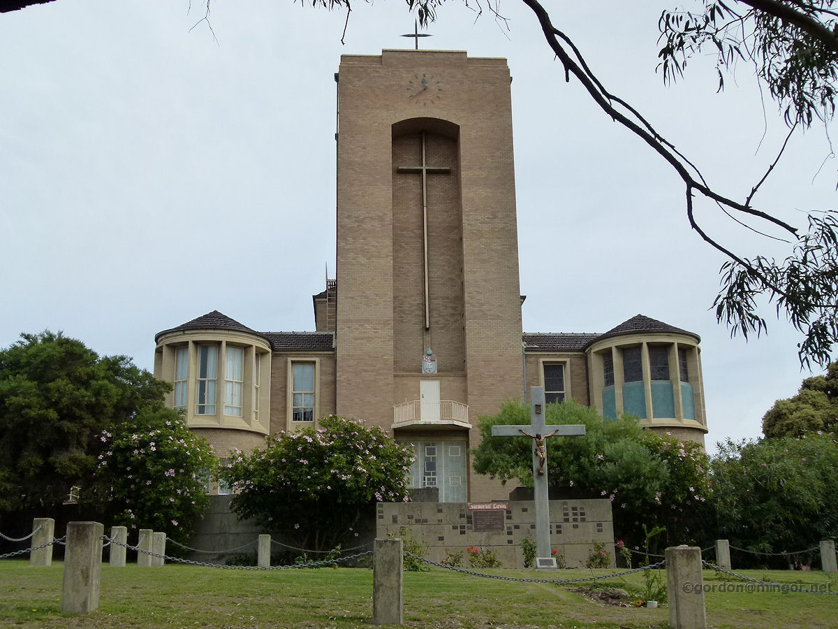
Bunbury - Catholic Cathedral The recently rebuilt St Patricks Cathedral sits upon its hill. This is viewed from Edward Street across vacant land that used to be the St John of God Hospital site. The Cathedral was dedicated in March 2011. The earlier Cathedral on this site was damaged beyond reasonable repair in a 2005 tornado. Before that it was damaged by Cyclone Alby in March 1978. July 2015. Photos Ref: BUNB069 |
||
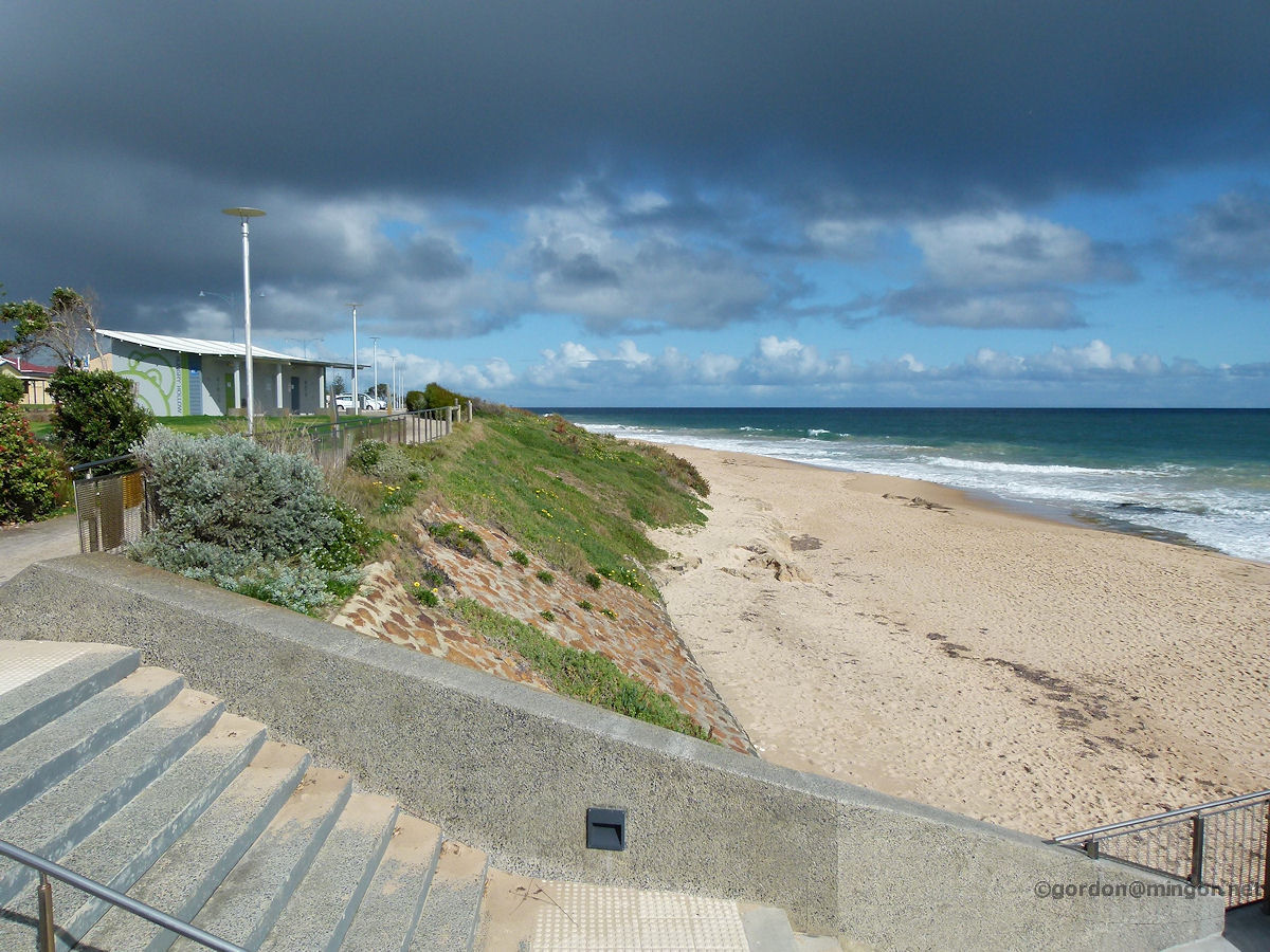 |
Bunbury - Hungry Hollow Hungry Hollow is a section of ocean beach a kilometre or so south of the Back Beach. This has been a very popular beach for many decades. July 2015. Photos Ref: BUNB070 |
||
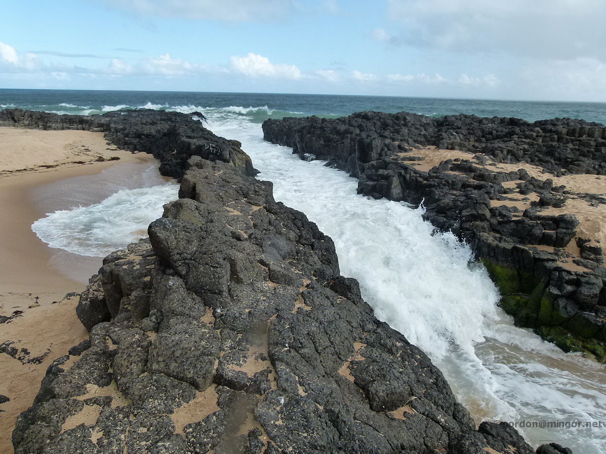 |
Bunbury - Foamy Channel Slightly north of the Back Beach are basalt rock formations which have been eroded over the millennia. Waves crash incessantly through this channel and up to the beach. Children in (at least) the 1960's used to call this Foamy Channel though it may have a more formal name. July 2015. Photos Ref: BUNB071 |
||
All images published on this website are copyright © of the webmaster. See About section for clarification and special schools permission |
|||